Selection Information
Please click on the image above to view our interactive map of proposed Land Grant selections.
Detail Selection Information:
Click on a region to see proposed selections.
Click on the name of a proposed selection to see a record of all actions, to date, for that selection.
April 13, 2026 - Atigun River Public Notice Closed
The public commenting period for the Atigun River Public Notice closed on April 13, 2026. Public comments submitted are being reviewed by state adjudicators and a decision will be issued by Alaska DNR in the future.
February 26, 2026 - Atigun River Public Notice
The State of Alaska's Department of Natural Resources issued a public notice for comment
on the Atigun River proposed Land Grant selection, containing approximately 3,968
acres of land (see map below). These lands are a proposed selection public noticed
by the state under provisions of the Consolidated Appropriations Act of 2023. The public notice can be found here: http://notice.alaska.gov/222839. Please review DNR's public notice for more information on how to comment. 
November 25, 2025 - Atigun River Selection Submitted to State
UA Land Management proposed the selection of lands near Atigun River. These lands lie with the township listed below. Please see the map below for a depiction of the lands.
Township 14 South, Range 10 East.
Comprising approximately 3,968 acres.

April 20, 2026 - Circle Hot Springs/Medicine Lake Public Notice Closed
The public commenting period for the Circle Hot Springs/Medicine Lake Public Notice closed on April 20, 2026. Public comments submitted are being reviewed by state adjudicators and a decision will be issued by Alaska DNR in the future.
March 12, 2026 - Circle Hot Springs/Medicine Lake Public Notice
The State of Alaska's Department of Natural Resources issued a public notice for comment
on the Circle Hot Springs/Medicine Lake proposed Land Grant selection, containing
approximately 2,417.5 acres of land (see map below). These lands are a proposed selection
public noticed by the state under provisions of the Consolidated Appropriations Act of 2023. The public notice can be found here: http://notice.alaska.gov/223009. Please review DNR's public notice for more information on how to comment. 
December 19, 2024 - Circle Hot Springs/Medicine Lake Selection Submitted to State
UA Land Management proposed the selection of lands near Circle Hot Springs at Medicine Lake. These lands lie with the township listed below. Please see the map below for a depiction of the lands.
Township 8 North, Range 16 East.
Comprising approximately 2,532.17 acres.

March 31, 2026 - Delong Mountains Public Notice Closed
The public commenting period for the Delong Mountains Public Notice closed on March 31, 2026. Public comments submitted are being reviewed by state adjudicators and a decision will be issued by Alaska DNR in the future.
February 13, 2026 - Delong Mountains Public Notice
The State of Alaska's Department of Natural Resources issued a public notice for comment
on the Delong Mountains proposed Land Grant selection, containing approximately 78,007
acres of land (see map below). These lands are a proposed selection public noticed
by the state under provisions of the Consolidated Appropriations Act of 2023. The public notice can be found here: http://notice.alaska.gov/222673. Please review DNR's public notice for more information on how to comment. 
November 25, 2025 - Delong Mountains Selection Submitted to State
UA Land Management proposed the selection of lands in the Delong Mountains. These lands lie with the township listed below. Please see the map below for a depiction of the lands.
Township 33 North, Range 18 West;
Township 33 North, Range 19 West;
Township 33 North, Range 20 West;
Township 33 North, Range 21 West;
Township 33 North, Range 22 West;
Township 33 North, Range 23 West;
Township 34 North, Range 21 West;
Township 34 North, Range 22 West;
Township 12 North, Range 50 West.
Comprising approximately 78,007 acres.

October 13, 2025 - Ester Dome Selection Submitted to the U.S. Bureau of Land Management
The University of Alaska and the State of Alaska's Department of Natural Resources have submitted a joint request for the Ester Dome selection to the U.S. Bureau of Land Management.
August 5, 2025 - Ester Dome Decision Issued by the State
The State of Alaska's Department of Natural Resources issued the decision to conditionally relinquish lands on Ester Dome, Fairbanks. This decision is in favor of the University’s proposed selection of approximately 317 acres. The next step is for UA Land Management and the State to submit the proposed selection to the U.S. Bureau of Land Management.
February 29, 2024 - Ester Dome Public Notice Closed
The public commenting period for the Ester Dome Public Notice closed on February 29, 2024. Public comments submitted are being reviewed by state adjudicators and a decision will be issued by Alaska DNR some time in the future.
January 26, 2024 - Ester Dome Public Notice Extended
The State of Alaska's Department of Natural Resources extended the December 19, 2023, public notice. The new deadline for public comment is February 29, 2024. The public notice and extension packet can be found here: https://aws.state.ak.us/OnlinePublicNotices/Notices/View.aspx?id=213642. Please review DNR's public notice for more information on how to comment.
December 19, 2023 - Ester Dome Public Notice
The State of Alaska's Department of Natural Resources issued a public notice for comment on the Ester Dome proposed selection. This proposed selection contains 316.65 acres of land on Ester Dome, Fairbanks, Alaska (see map below). These lands are a proposed selection to be public noticed under the Consolidated Appropriations Act of 2023. The public notice can be found here: https://aws.state.ak.us/OnlinePublicNotices/Notices/View.aspx?id=213642. Please review DNR's public notice for more information on how to comment.
November 17, 2023 - Ester Dome Selection Submitted to State
UA Land Management proposed the selection of lands on Ester Dome near Fairbanks. These lands lie with the townships listed below. Please see the map below for a depiction of the lands.
Township 1 North, Range 2 West.
Comprising 316.65 acres.

April 3, 2026 - Kauk River Public Notice Closed
The public commenting period for the Kauk River Public Notice closed on April 3, 2026. Public comments submitted are being reviewed by state adjudicators and a decision will be issued by Alaska DNR in the future.
February 19, 2026 - Kauk River Public Notice
The State of Alaska's Department of Natural Resources issued a public notice for comment
on the Kauk River proposed Land Grant selection, containing approximately 25,441 acres
of land (see map below). These lands are a proposed selection public noticed by the
state under provisions of the Consolidated Appropriations Act of 2023. The public notice can be found here: http://notice.alaska.gov/222729. Please review DNR's public notice for more information on how to comment. 
December 19, 2024 - Kauk River Selection Submitted to State
UA Land Management proposed the selection of lands near the Kauk River, within and just North of the Selawik Hills. These lands lie with the township listed below. Please see the map below for a depiction of the lands.
Township 10 North, Range 8 West.
Comprising approximately 25,441 acres.

March 26, 2026 - Pediment Creek Public Notice Closed
The public commenting period for the Pediment Public Notice closed on March 26, 2026. Public comments submitted are being reviewed by state adjudicators and a decision will be issued by Alaska DNR in the future.
February 19, 2026 - Pediment Creek Public Notice
The State of Alaska's Department of Natural Resources issued a public notice for comment
on the Pediment Creek proposed Land Grant selection, containing approximately 15,329
acres of land (see map below). These lands are a proposed selection public noticed
by the state under provisions of the Consolidated Appropriations Act of 2023. The public notice can be found here: http://notice.alaska.gov/222709. Please review DNR's public notice for more information on how to comment. 
November 25, 2025 - Pediment Creek Selection Submitted to State
UA Land Management proposed the selection of lands near Pediment Creek. These lands lie with the townships listed below. Please see the map below for a depiction of the lands.
Township 8 South, Range 4 West;
Township 8 South, Range 5 West;
Township 8 South, Range 6 West.
Comprising approximately 15,329 acres.

April 6, 2026 - Ray Mountains Selection Submitted to the U.S. Bureau of Land Management
The University of Alaska and the State of Alaska's Department of Natural Resources have submitted a joint request for the Ray Mountains selection to the U.S. Bureau of Land Management.
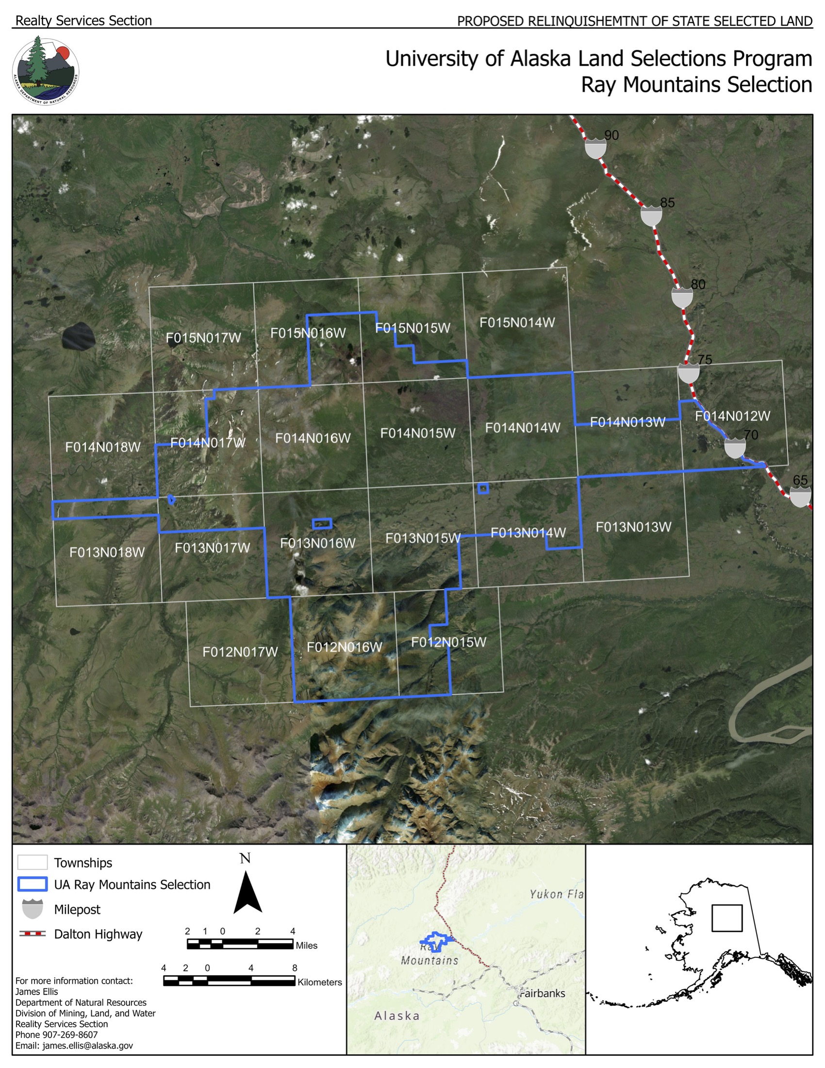
March 2, 2026 - Ray Mountains Decision Issued by the State
The State of Alaska's Department of Natural Resources issued the decision to conditionally relinquish the Ray Mountains selection with modifications.
October 9, 2025 - Ray Mountains Public Notice Closed
The public commenting period for the Ray Mountains Public Notice closed on October 9, 2025. The Alaska Department of Natural Resources extended the commenting period from the original closing date of September 9, 2025 to provide additional time for comment. Public comments submitted are being reviewed by state adjudicators and a decision will be issued by Alaska DNR in the future.
August 7, 2025 - Ray Mountains Public Notice
The State of Alaska's Department of Natural Resources issued a public notice for comment on the Ray Mountains proposed selection, containing approximately 219,924 acres of land (see map below). These lands are a proposed selection public noticed by the state under provisions of the Consolidated Appropriations Act of 2023. The public notice can be found here: http://notice.alaska.gov/220422. Please review DNR's public notice for more information on how to comment.
June 28, 2024 - Ray Mountains Selection Addition
This proposed amendment is approximately 151,172 acres, in addition to the existing proposed selection. These lands lie with the townships listed below. Please see the map below for a depiction of this modification. The new combined total is 220,082 acres.
Township 12 North, Range 15 West;
Township 12 North, Range 16 West;
Township 13 North, Range 14 West;
Township 13 North, Range 15 West;
Township 13 North, Range 16 West;
Township 14 North, Range 12 West;
Township 14 North, Range 13 West;
Township 14 North, Range 14 West;
Township 14 North, Range 15 West;
Township 14 North, Range 16 West;
Township 15 North, Range 15 West;
Township 15 North, Range 16 West.

July 7, 2023 - Ray Mountains Selection Modified
Approximately 15,360 acres of land within Township 13 North, Range 17 West, Fairbanks Meridian, were removed and added to the Spooky Valley proposed selection. The total acreage for this proposed selection now totals 68,910 acres, more or less. See map below for a depiction of this modification.
June 6, 2022 - Ray Mountains Selection Submitted to State
UA Land Management proposed the selection of lands in the Ray Mountains. These lands lie with the townships listed below. Please see the map below for a depiction of the lands.
Township 13 North, Range 14 West;
Township 13 North, Range 14 West;
Township 13 North, Range 15 West;
Township 13 North, Range 16 West;
Township 13 North, Range 17 West;
Township 13 North, Range 18 West;
Township 14 North, Range 14 West;
Township 14 North, Range 15 West;
Township 14 North, Range 16 West;
Township 14 North, Range 17 West.
Aggregating 84,270 acres, more or less.

April 3, 2026 - Selawik Hills Public Notice Closed
The public commenting period for the Selawik Hills Public Notice closed on April 3, 2026. Public comments submitted are being reviewed by state adjudicators and a decision will be issued by Alaska DNR in the future.
February 19, 2026 - Selawik Hills Public Notice
The State of Alaska's Department of Natural Resources issued a public notice for comment
on the Selawik Hills proposed Land Grant selection, containing approximately 25,250
acres of land (see map below). These lands are a proposed selection public noticed
by the state under provisions of the Consolidated Appropriations Act of 2023. The public notice can be found here: http://notice.alaska.gov/222729. Please review DNR's public notice for more information on how to comment. 
November 25, 2025 - Selawik Hills Selection Submitted to State
UA Land Management proposed the selection of lands near Selawik Hills. These lands lie with the townships listed below. Please see the map below for a depiction of the lands.
Township 7 North, Range 9 West;
Township 8 North, Range 9 West.
Comprising approximately 25,250 acres.

May 24, 2024 - Spooky Valley Selection Submitted to the U.S. Bureau of Land Management
The University of Alaska and the State of Alaska's Department of Natural Resources have submitted a joint request for the Spooky Valley selection to the U.S. Bureau of Land Management. This is the first selection to advance to the federal government.
January 12, 2024 - Spooky Valley Decision Issued by State
The State of Alaska's Department of Natural Resources issued the decision to conditionally relinquish lands in the Ray Mountains. This decision is in favor of the University’s proposed Spooky Valley selection of approximately 96,406 acres. The next step is for UA Land Management and the State to submit the proposed selection to the Bureau of Land Management. The decision can be found here: https://aws.state.ak.us/OnlinePublicNotices/Notices/View.aspx?id=213911.
September 8, 2023 - Spooky Valley Public Notice Closed
The public commenting period for the Ray Mountains Public Notice closed on September 8, 2023. The Alaska Department of Natural resources extended the commenting period from the original closing date of August 23, 2023 to provide additional time for comment. Public comments submitted are being reviewed by state adjudicators and a decision will be issued by Alaska DNR some time in the future.
July 19, 2023 - Spooky Valley Public Notice
The State of Alaska's Department of Natural Resources issued a public notice for comment on the Spooky Valley proposed selection. This proposed selection contains approximately 96,406 acres of the Ray Mountains, that includes Spooky Valley, located about 120 miles northwest of Fairbanks, Alaska (see map below). These lands are a proposed selection to be public noticed under the Consolidated Appropriations Act of 2023. The public notice can be found here: https://aws.state.ak.us/OnlinePublicNotices/Notices/View.aspx?id=211883.

July 19, 2023 - Spooky Valley Selection Modification
Approximately 7,620 acres of land within Township 10 North, Range 17 West, Fairbanks Meridian, were added to this proposed selection to meet township minimums required by the Bureau of Land Management. The total acreage for this proposed selection now totals 96,406 acres, more or less. See map below for a depiction of this modification.
July 7, 2023 - Spooky Valley Selection Modified
Approximately 15,360 acres of land within Township 13 North, Range 17 West, Fairbanks Meridian, were removed from the Ray Mountains proposed selection and added to this proposed selection. The total acreage for this proposed selection now totals 88,786 acres, more or less. See map below for a depiction of this modification.
September 16, 2022 - Spooky Valley Selection Submitted to State
UA Land Management proposed the selection of lands in the Ray Mountains. These lands lie with the townships listed below. Please see the map below for a depiction of the lands.
Township 10 North, Range 17 West;
Township 10 North, Range 18 West;
Township 11 North, Range 17 West;
Township 11 North, Range 18 West;
Township 12 North, Range 17 West;
Township 12 North, Range 18 West;
Aggregating to 73,442 acres, more or less.

October 13, 2025 - Toolik Station Selection Submitted to the U.S. Bureau of Land Management
The University of Alaska and the State of Alaska's Department of Natural Resources have submitted a joint request for the Toolik Station selection to the U.S. Bureau of Land Management.
August 5, 2025 - Toolik Station Decision Issued by the State
The State of Alaska's Department of Natural Resources issued the decision to conditionally relinquish the Toolik Station selection. This decision is in favor of the University’s proposed selection of approximately 5,775 acres. The next step is for UA Land Management and the State to submit the proposed selection to the U.S. Bureau of Land Management.
April 1, 2025 - Toolik Station Public Notice Closed
The public commenting period for the Toolik Station Public Notice closed on April 1, 2025. Public comments submitted are being reviewed by state adjudicators and a decision will be issued by Alaska DNR some time in the future.
February 20, 2025 - Toolik Station Public Notice
The State of Alaska's Department of Natural Resources issued a public notice for comment of the Toolik Station proposed selection. This selection includes approximately 5,775 acres of land along the Dalton Highway at Toolik Lake, including the UAF Institute of Arctic Biology Toolik Field Station, which is currently leased from the Bureau of Land Management (see map below). These lands are a proposed selection public noticed by the state under provisions of the Consolidated Appropriations Act of 2023. The public notice can be found here: https://aws.state.ak.us/OnlinePublicNotices/Notices/View.aspx?id=218575. Please review DNR's public notice for more information on how to comment.
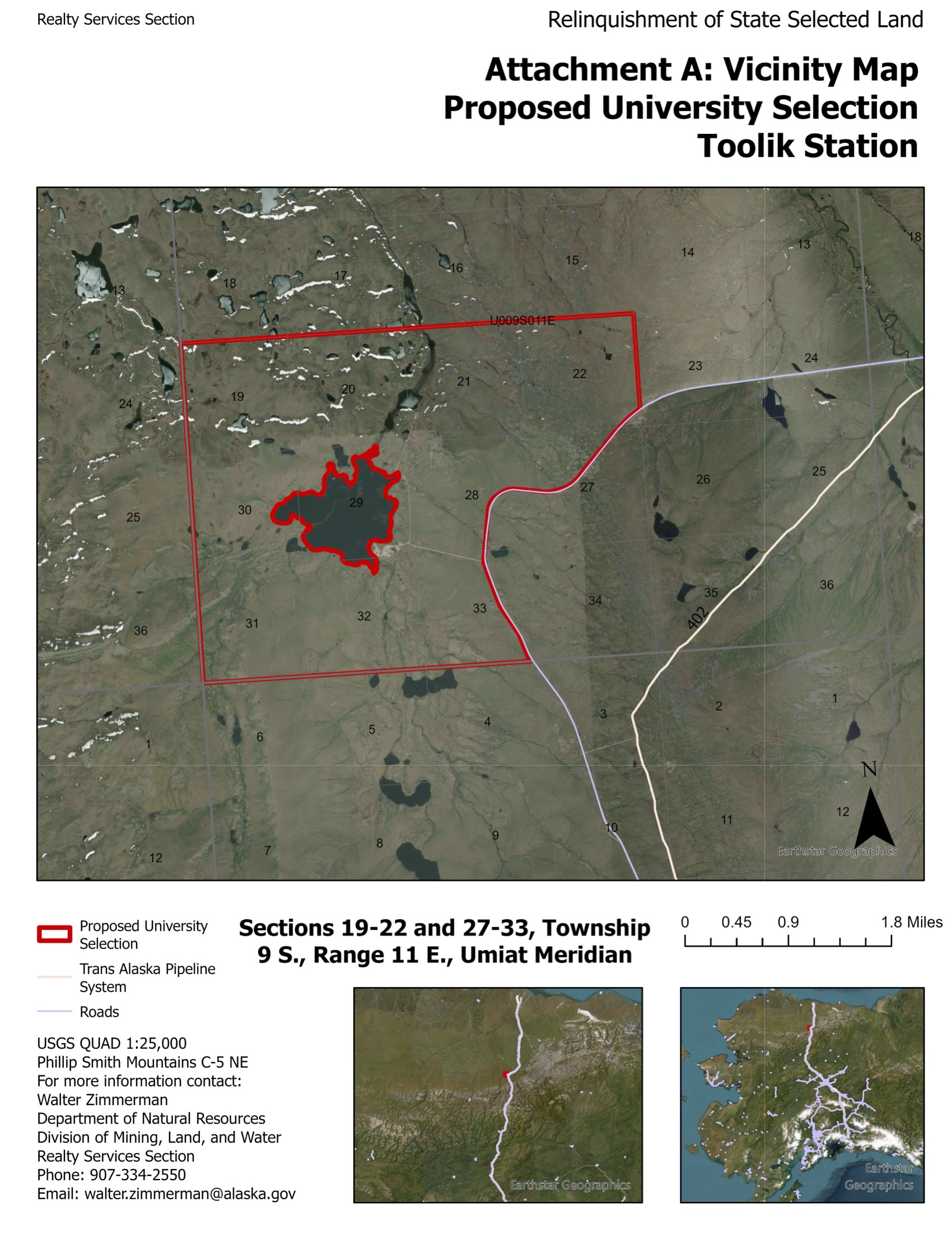
May 31, 2024 - Toolik Station Selection Submitted to State
UA Land Management proposed the selection of lands along the Dalton Highway at Toolik Lake. These lands include the University of Alaska Fairbanks Institute of Arctic Biology Toolik Field Station which is currently leased from the Bureau of Land Management by UAF. These lands lie within the township listed below. Please see the map below for a depiction of the lands.
Township 9 South, Range 11 East.
Comprising 5,775 acres, more or less.

March 31, 2026 - West Fork Wulik River Public Notice Closed
The public commenting period for the West Fork Wulik River Public Notice closed on March 31, 2026. Public comments submitted are being reviewed by state adjudicators and a decision will be issued by Alaska DNR in the future.
February 13, 2026 - West Fork Wulik River Public Notice
The State of Alaska's Department of Natural Resources issued a public notice for comment
on the West Fork Wulik River proposed Land Grant selection, containing approximately
8,864 acres of land (see map below). These lands are a proposed selection public noticed
by the state under provisions of the Consolidated Appropriations Act of 2023. The public notice can be found here: http://notice.alaska.gov/222673. Please review DNR's public notice for more information on how to comment. 
November 25, 2025 - West Fork Wulik River Selection Submitted to State
UA Land Management proposed the selection of lands near the West Fork Wulik River. These lands lie with the township listed below. Please see the map below for a depiction of the lands.
Township 31 North, Range 22 West.
Comprising approximately 8,864 acres.

Click on the name of a proposed selection to see a record of all actions, to date, for that selection.
April 9, 2026 - Elrington Public Notice Closed
The public commenting period for the Elrington Public Notice closed on April 9, 2026. Public comments submitted are being reviewed by state adjudicators and a decision will be issued by Alaska DNR in the future.
March 5, 2026 - Elrington Public Notice
The State of Alaska's Department of Natural Resources issued a public notice for comment
on the Elrington proposed Land Grant selection, containing approximately 5 acres of
land (see map below). These lands are a proposed selection public noticed by the state
under provisions of the Consolidated Appropriations Act of 2023. The public notice can be found here: http://notice.alaska.gov/222944. Please review DNR's public notice for more information on how to comment. 
October 11, 2023 - Elrington Selection Submitted to State
UA Land Management proposed the selection of lands on Elrington Island south of Chenega. These lands lie with the townships listed below. Please see the map below for a depiction of the lands.
Township 2 South, Range 8 East,
Section 2.
Comprising 5 acres, more or less.

October 11, 2023 - Fish Lake Selection Submitted to State
UA Land Management proposed the selection of lands on Fish Lake north of Glennallen. These lands lie with the townships listed below. Please see the map below for a depiction of the lands.
Township 9 North, Range 4 West,
Section 13.
Comprising 417 acres, more or less.

April 1, 2026 - Honolulu Pass Public Notice Closed
The public commenting period for the Honolulu Pass Public Notice closed on April 1, 2026. The Alaska Department of Natural Resources extended the commenting period from the original closing date of March 20, 2026 to provide additional time for comment. Public comments submitted are being reviewed by state adjudicators and a decision will be issued by Alaska DNR in the future.
February 12, 2026 - Honolulu Pass Public Notice
The State of Alaska's Department of Natural Resources issued a public notice for comment
on the Honolulu Pass proposed Land Grant selection, containing approximately 58,893
acres of land (see map below). These lands are a proposed selection public noticed
by the state under provisions of the Consolidated Appropriations Act of 2023. The public notice can be found here: http://notice.alaska.gov/222588. Please review DNR's public notice for more information on how to comment. 
December 19, 2024 - Honolulu Pass Selection Submitted to State
UA Land Management proposed the selection of lands near Honolulu Pass. These lands lie with the township listed below. Please see the map below for a depiction of the lands.
Township 21 South, Range 8 West,
Township 21 South, Range 9 West,
Township 22 South, Range 8 West,
Township 22 South, Range 9 West.
Comprising approximately 58,893 acres.

October 11, 2023 - Klutina Selection Submitted to State
UA Land Management proposed the selection of lands on Klutina Lake. These lands lie with the townships listed below. Please see the map below for a depiction of the lands.
Township 1 South, Range 4 West,
Sections 20, 28, 29, 32, and 33.
Aggregating to 2,698 acres, more or less.

November 15, 2023 - Mentasta Public Notice Closed
The public commenting period for the Mentasta Public Notice closed on November 15, 2023. Public comments submitted are being reviewed by state adjudicators and a decision will be issued by Alaska DNR some time in the future.
October 11, 2023 - Mentasta Public Notice
The State of Alaska's Department of Natural Resources issued a public notice for comment
on the Mentasta proposed selection. This proposed selection contains approximately
24,160 acres of land north of Mentasta Lake, west of the Tok Cutoff Highway, and south
of the Tok River in the Mentasta and Dry Tok Creek Areas (see map below). These lands
are a proposed selection to be public noticed under the Consolidated Appropriations Act of 2023. The public notice can be found here: https://aws.state.ak.us/OnlinePublicNotices/Notices/View.aspx?id=212874. Please review DNR's public notice for more information on how to comment. 
September 16, 2022 - Mentasta Selection Submitted to State
UA Land Management proposed the selection of lands near Mentasta Lake. These lands lie with the townships listed below. Please see the map below for a depiction of the lands.
Township 14 North, Range 9 East;
Township 15 North, Range 8 East;
Aggregating to 26,048.95 acres, more or less.

October 11, 2023 - Old Man Lake Selection Submitted to State
UA Land Management proposed the selection of lands on Old Man Lake northwest of Mendeltna. These lands lie with the townships listed below. Please see the map below for a depiction of the lands.
Township 4 North, Range 8 West,
Sections 10 and 14.
Aggregating to 280 acres, more or less.

October 11, 2023 - Saint Anne Lake Selection Submitted to State
UA Land Management proposed the selection of lands on Saint Anne Lake south-southwest of Glennallen. These lands lie with the townships listed below. Please see the map below for a depiction of the lands.
Township 1 North, Range 5 West,
Sections 25 and 36.
Aggregating to 1,065.57 acres, more or less.

April 28, 2026 - Slana Public Notice Closed
The public commenting period for the Slana Public Notice closed on April 28, 2026. The Alaska Department of Natural Resources extended the commenting period from the original closing date of April 21, 2026 to provide additional time for comment. Public comments submitted are being reviewed by state adjudicators and a decision will be issued by Alaska DNR in the future.
March 17, 2026 - Slana Public Notice
The State of Alaska's Department of Natural Resources issued a public notice for comment
on the Slana proposed Land Grant selection, containing approximately 613 acres of
land (see map below). These lands are a proposed selection public noticed by the state
under provisions of the Consolidated Appropriations Act of 2023. The public notice can be found here: http://notice.alaska.gov/223119. Please review DNR's public notice for more information on how to comment. 
October 11, 2023 - Slana Selection Submitted to State
UA Land Management proposed the selection of lands on Nabesna Road near Slana. These lands lie with the townships listed below. Please see the map below for a depiction of the lands.
Township 11 North, Range 8 East,
Section 28.
Comprising 613 acres, more or less.

December 19, 2024 - South Fork Kuskokwim Selection Submitted to State
UA Land Management proposed the selection of lands near Farewell Lake and the South Fork Kuskokwim River. These lands lie with the township listed below. Please see the map below for a depiction of the lands.
Township 2 North, Range 23 West.
Comprising approximately 598.69 acres.

June 6, 2022 - Susitna Selection Submitted to State
UA Land Management proposed the selection of lands along the Denali Highway. These lands lie with the townships listed below. Please see the map below for a depiction of the lands.
Township 21 South, Range 1 East;
Township 21 South, Range 2 East;
Township 22 South, Range 2 East;
Township 22 South, Range 3 East;
Aggregating 7,520 acres, more or less.

June 6, 2022 - Swede Lake Selection Submitted to State
UA Land Management proposed the selection of lands along the Denali Highway at Swede Lake. These lands lie with the townships listed below. Please see the map below for a depiction of the lands.
Township 21 South, Range 9 East;
Township 21 South, Range 10 East;
Township 22 South, Range 9 East;
Township 22 South, Range 10 East;
Aggregating 7,042 acres, more or less.

October 11, 2023 - Tazlina Selection Submitted to State
UA Land Management proposed the selection of lands on Tazlina Lake at the mouth of the Nelchina River. These lands lie with the townships listed below. Please see the map below for a depiction of the lands.
Township 2 North, Range 7 West,
Sections 2, 11, and 12.
Aggregating to 1,222.38 acres, more or less.

October 11, 2023 - Tustumena Selection Submitted to State
UA Land Management proposed the selection of lands on Tustumena Lake and the Kasilof River near southeast of Kasilof. These lands lie with the townships listed below. Please see the map below for a depiction of the lands.
Township 2 North, Range 11 West,
Sections 1, 2, 3, 4, 9, 10, 11, 12, 13, 14, 15, 16, 23, and 27.
Aggregating to 6,575 acres, more or less.

April 1, 2026 - Watana Creek Public Notice Closed
The public commenting period for the Watana Creek Public Notice closed on April 1, 2026. The Alaska Department of Natural Resources extended the commenting period from the original closing date of March 19, 2026 to provide additional time for comment. Public comments submitted are being reviewed by state adjudicators and a decision will be issued by Alaska DNR in the future.
February 13, 2026 - Watana Creek Public Notice
The State of Alaska's Department of Natural Resources issued a public notice for comment
on the Watana Creek proposed Land Grant selection, containing approximately 37,055
acres of land (see map below). These lands are a proposed selection public noticed
by the state under provisions of the Consolidated Appropriations Act of 2023. The public notice can be found here: http://notice.alaska.gov/222672. Please review DNR's public notice for more information on how to comment. 
December 19, 2024 - Watana Creek Selection Submitted to State
UA Land Management proposed the selection of lands near Watana Creek. These lands lie with the township listed below. Please see the map below for a depiction of the lands.
Township 32 North, Range 8 East,
Township 32 North, Range 9 East,
Township 33 North, Range 8 East,
Township 33 North, Range 9 East.
Comprising approximately 37,055 acres.

Click on the name of a proposed selection to see a record of all actions, to date, for that selection.
October 22, 2024 - Upper Klehini Selection Change in Status
The Upper Klehini selection was previously selected by the Mental Health Trust under the 2009 Final Settlement Agreement, and the Bureau of Land Management has signed the agreement. Therefore the State is unable to relinquish the lands for the University.
October 11, 2023 - Upper Klehini Selection Submitted to State
UA Land Management proposed the selection of lands on the Old Haines Highway near Porcupine. These lands lie with the townships listed below. Please see the map below for a depiction of the lands.
Township 28 South, Range 54 East,
Section 21.
Comprising 30 acres, more or less.

October 11, 2023 - Lower Klehini Selection Submitted to State
UA Land Management proposed the selection of lands on Haines Highway west-northwest of Klukwan. These lands lie with the townships listed below. Please see the map below for a depiction of the lands.
Township 28 South, Range 56 East,
Section 31.
Comprising 28.27 acres, more or less.

October 13, 2025 - Upper Chilkat selection submitted to the U.S. Bureau of Land Management
The University of Alaska and the State of Alaska's Department of Natural Resources have submitted a joint request for the Upper Chilkat selection to the U.S. Bureau of Land Management.
August 5, 2025 - Upper Chilkat Decision Issued by the State
The State of Alaska's Department of Natural Resources issued the decision to conditionally relinquish the Upper Chilkat selection. This decision is in favor of the University’s proposed selection of approximately 4.406 acres. The next step is for UA Land Management and the State to submit the proposed selection to the U.S. Bureau of Land Management.
July 2, 2024 - Upper Chilkat Public Notice Closed
The public commenting period for the Upper Chilkat Public Notice closed on July 2, 2024. Public comments submitted are being reviewed by state adjudicators and a decision will be issued by Alaska DNR some time in the future.
May 31, 2024 - Upper Chilkat Public Notice
The State of Alaska's Department of Natural Resources issued a public notice for comment of the Upper Chilkat proposed selection. This proposed selection contains approximately 4,406 acres of land along the Chilkat River outside of the Chilkat Bald Eagle Preserve on the U.S.A. and Canadian border approximately 18 miles north of Klukwan, Alaska and approximately 33 miles northwest of Haines, Alaska (see map below). These lands are a proposed selection public noticed by the state under provisions of the Consolidated Appropriations Act of 2023. The public notice can be found here: https://aws.state.ak.us/OnlinePublicNotices/Notices/View.aspx?id=215598. Please review DNR's public notice for more information on how to comment.
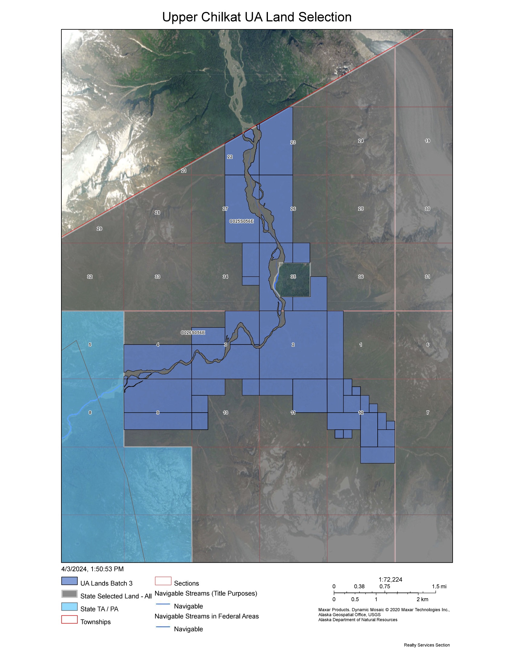
October 11, 2023 - Upper Chilkat Selection Submitted to State
UA Land Management proposed the selection of lands along the Upper Chilkat River on the USA and Canada border. These lands lie with the townships listed below. Please see the map below for a depiction of the lands.
Township 25 South, Range 56 East;
Township 26 South, Range 56 East.
Aggregating to 4,406 acres, more or less.
