Documenting the Language of Landscape
Carolyn O'Meara (ckomeara [at] unam.mx)
Gary Holton (holton [at] hawaii.edu)
 This workshop will introduce students to methodology of ethnophysiography, which can
be used to document linguistic categorization within the landscape domain. We begin
with a brief overview of the significance of landscape as a linguistic domain, noting
areas of interest in linguistics, geography, philosophy and anthropology. We then
review published case studies in order to learn how to collect landscape-related data,
Finally we consider applications to community mapping projects, creation of place
name inventories, and the development of teaching materials for use in or outside
of the classroom.
This workshop will introduce students to methodology of ethnophysiography, which can
be used to document linguistic categorization within the landscape domain. We begin
with a brief overview of the significance of landscape as a linguistic domain, noting
areas of interest in linguistics, geography, philosophy and anthropology. We then
review published case studies in order to learn how to collect landscape-related data,
Finally we consider applications to community mapping projects, creation of place
name inventories, and the development of teaching materials for use in or outside
of the classroom.
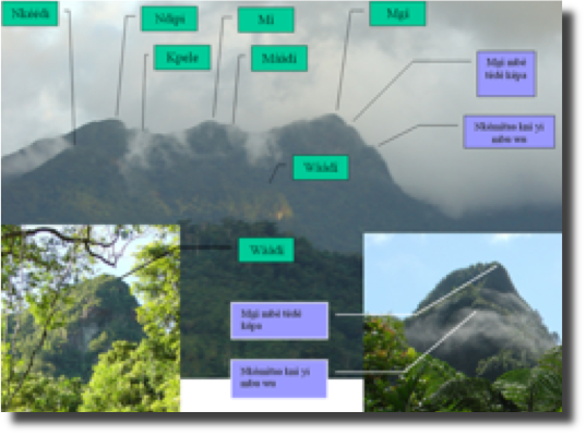
Although landscape permeates the human experience, the domain of landscape is a particularly challenging one for language documentation. Recent research has shown that typical landscape categories such as MOUNTAIN and RIVER are not universal semantic primitives but are in fact realized differently in different languages. Landscape is an essentially continuous domain, and the segmentation of this domain into discrete categories reflects a linguistic (and cultural) choice. Simply glossing a term as ‘mountain’ fails to capture the nature of this categorization. This workshop will provide the tools necessary to avoid such pitfalls.
download pdf version of this syllabus
Supplies needed
- A laptop, preferably with QGIS installed (http://www.qgis.org/en/site/)
- Landscape-related data from a particular language the student is working on
Student learning outcomes
At the end of this course students will be able to:
- describe the significance of landscape as a linguistic domain
- provide examples of how putatively universal categories such as MOUNTAIN and RIVER are realized across various languages
- know how to collect and identify generic landscape terms and toponyms
- use QGIS software for managing geo-linguistic data
Instructional methods
Workshop delivery will be a balance between lecture, discussion of readings and working through case studies. Participants will be encouraged to bring their own field data to work through in class.
Daily Schedule
- Day 1 (June 20). Introduction. Why is the landscape domain interesting and why should we document it?
- Day 2 (June 21). Case studies
- Day 3 (June 22). Methods of data collection in the field
- Day 4 (June 23). Applied ethnophysiography
Readings
Course readings are available online and via the flash drive distributed with registration. See the extended bibliography below. Please reading the required readings prior to each class meeting.
Evaluation
Workshops will be Pass/Fail. Students will be required to attend each workshop session and to complete a short (< 5 page) proposal to document landscape categories and/or toponyms in a language. Receiving a “pass” grade requires all of the following:
- full attendance at each class meeting
- completion of short (< 5 page) proposal
- brief presentation (5-10 minutes) of proposal at final class meeting
Disabilities services
The Office of Disability Services implements the Americans with Disabilities Act (ADA), and insures that UAF students have equal access to the campus and course materials. The instructor will work with the Office of Disabilities Services (208 WHIT, 474-5655) to provide reasonable accommodation to students with disabilities.Student learning outcomes